|
On May 19th I was sitting in my garden enjoying the hot sunshine, the sky was blue, stable, and perfect. It had been yet another wonderful day of high pressure weather which we had been experiencing on and off over the last two weeks and I was making the most of the warm sunshine by getting caught up with the garden and exercising. Later Roisin asked if I wanted to go for an evening walk, I most certainly did, and since the sky was quiet I didn't take any camera gear with me, not even my phone (something I rarely ever do), I just wanted to enjoy our walk and the peace.
We drove to the countryside outside Cookstown then began walking along a back road and it was then that we were astonished to see several decent updraught towers standing out with striking clarity against the western sky. I was taken aback as I didn't realize there was any instability this day, there must have been some which suddenly unleashed its energy near the end of a hot day perhaps aided by cooling air aloft. Even though these updraughts were capped they still looked very solid with cumulus knuckles around the tops. As if this wasn't good enough the tallest tower was surrounded by a spectacular pileus cap, the largest I've ever seen, gleaming milky white and transparent, it was sharp like a disk, in fact, it looked like an elongated version of the rings of Saturn.
The updraught punched through this then more pileus formed on several towers, perhaps five all at once, the sun cast the shadows of the updraught knuckles upon the pileus disks, the towers being partially back-lit looked dark blue with intense white edges capped off by multiple white angelic pileus, there was even a double stacked pileus too and the entire formation was surrounded by blue sky. These were the most spectacular pileus formations I've ever observed in my life and I cursed myself for not bringing any camera, Roisin didn't even have her phone either, so I had to except that I wasn't going to get any images and just enjoy the visual experience. As we walked along the back roads the view across the countryside was breathtaking with lush green sunlit fields curving gracefully across the landscape with isolated trees and cows perched on the grass enjoying the heat, and above all this were the menacing towers and beautiful pileus, it was the perfect moment, almost like a scene from Kansas (green version).
 |
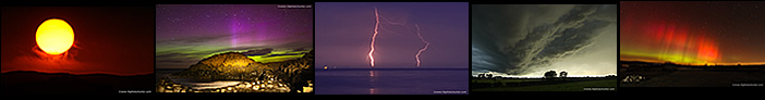
After completing our walk 30 min's later we raced back home and grabbed the camera gear, even though the best of the display was over there were still some pileus on show and new towers were appearing in the wake of the recent updraughts. I shot this from the yard with the 100-400mm then Roisin, Rhua and I jumped in the car and went on an unexpected evening chase. We were not expecting actual storms of course however the bases below these towers needed to be watched for funnel clouds. We went to the west side of town, took some random country road we had never even been on before, then pulled into a lay by near a gate to a farmer's field and I got the drone up and observed these bases for half an hour, by which time the convection began to wind down so we began our drive back home. Roisin and I were both on a natural high from the experience, I said to Roisin with absolute sincerity that this was a very good omen of storm days to come this season, I was certain of it, but little did I know how correct my instincts would turn out to be.
The following day, May 20th, looked to be an action-packed day for thunderstorms with 800-1500j/kg of CAPE, decent dew points, temperatures expected to surpass 20 degrees C and cold air aloft with tops experiencing -50 degree C temperatures, this was a recipe for big thunderstorms. There was no strong speed shear so storms would be pulsey in nature however Owain Rice informed me there was 20 knots of low level shear, perhaps just enough to produce multicell traits for a time. Furthermore a very well defined convergence zone was showing over the far west of the country so funnel clouds were also possible.
The CAPE favored the midlands and west, however it was the west which had the coldest air aloft and convergence and although some models where showing storms over the Sperrins near my location I wasn't convinced, I knew that west was best. AROME indicated that Fermanagh, west Omagh, Sligo and Donegal where the best locations for storms, based on my own forecast I chose Donegal as the best target area where Cz, highest CAPE, coldest tops and lift from hills would all overlap. The Met Office issued a yellow warning for thunderstorms and heavy rainfall while Met Eireann issued an orange thunderstorm warning which included Sligo and Donegal. I was mad looking to chase, however I knew I would have to sit this one out as I had an issue with the van which wouldn't be sorted until the next day, Roisin would be away all evening in her car so I was housebound. It looked like it would be a day of radar watching instead.
It was then that I got a message from Nigel McFarland, he was going chasing and asked if I wanted picked up, I was blown away by this opportunity, to say that this was a kind act would be an understatement as Nigel could have drove west into Donegal himself a lot quicker but instead he had to do a longer drive well out of his way to pick me up. This I was most grateful for, I don't like missing out on chase days, especially days with juicy air and strong CAPE, I was delighted knowing we would be hitting the road. However there would be no time for relaxing, Nigel would be collecting me at 15.00 then we would drive straight to Donegal so every minute counted.
I checked radar, storms had already exploded early in the day, even earlier than the models had indicated with Donegal seeing intense lightning rates and precip already which was a very good sign. This was after midday, would the storms hold until we got there? GFS showed CAPE staying in the Donegal area to 20.00 or later so I knew we were good. John Fagan sent an image on fb messenger of the stops of the Donegal storms from Omagh and they looked spectacular, soon others were posting images of huge towers to the west, the convection was unmistakable, even to those who were untrained in convective clouds. I got all the gear ready, Nigel arrived bang on 15.00 then Rhua and I got in his car and we hit the road immediately.
Cookstown was covered by low grey cloud all day however to the west skies were crystal clear with intense solar heating and it was this which was helping fuel storms. Nigel drove while I navigated using radar, once we got outside Omagh we got treated to a beautiful display of white sunlit convection all over the west/north west sky sectors with other cells to the southwest. We knew we were looking at serious convection, the Donegal cell was a massive white mountain with solid anvil and along its side and rear flanks where numerous solid towers exploding aloft. It was obvious from this visual and radar that the Donegal cell was back-building with the storm's outflow triggering new cells nearby, all along the convergence zone, this boded well for us.
Nigel passed his phone to me for a look, on social media images had come in of a spectacular funnel cloud captured near Derry/Londonderry, a very large dark substantial funnel it was too. Easily the most photogenic funnel over Northern Ireland since the Lough Neagh waterspout in 2024, the images had us on high alert. There was cell near that area which must have produced it however the area we where targeting had even better convergence so we still had a chance of seeing another vortex. Originally our plan was to stop in Kesh as a base but we didn't need to, storms where very active in the entire west, however it was the Donegal area which was still producing with huge white cores on radar, that was the place to be. We drove on through Pettigo then crossed the border into Donegal, we didn't want to go much further as the last thing we needed was to be sitting under precip so we needed a location with an elevated view at a specific distance from the storm and we found it on a back road at a location where Paul Martin and I had chased before. We where now positioned to the southeast of the back-building cores on radar perfectly placed for storm spotting.
 |
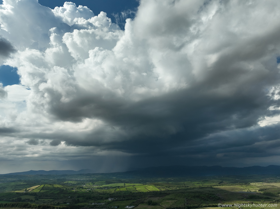
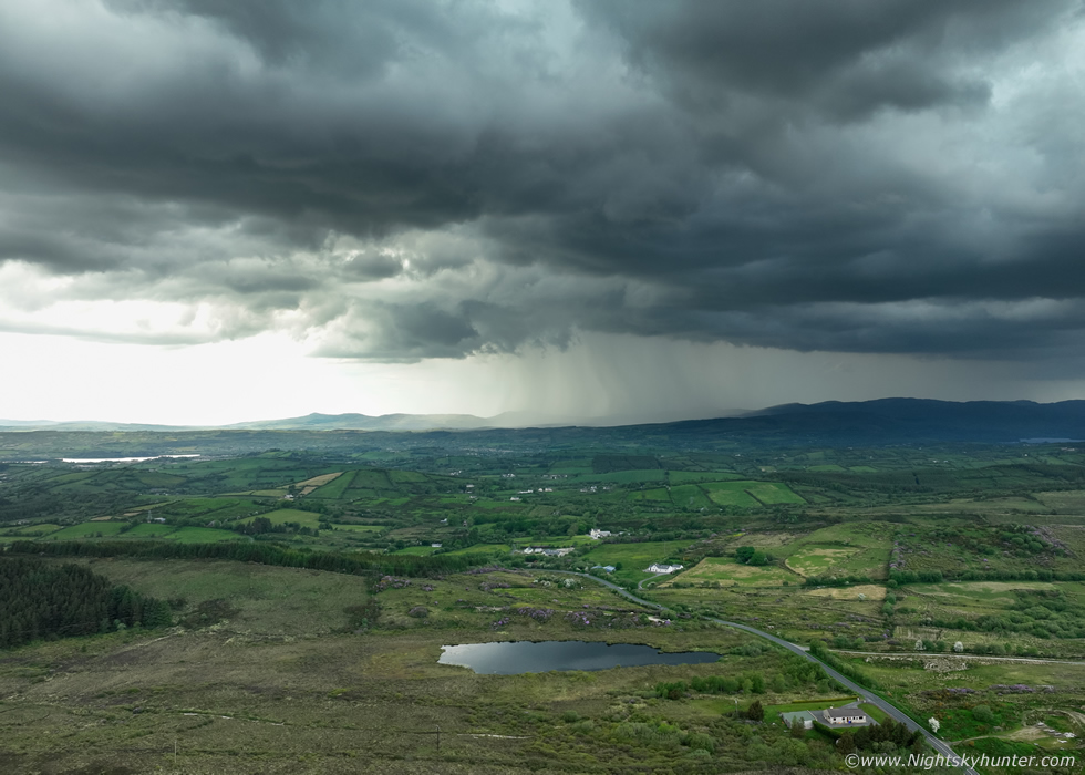
We would never shift from this location for the remainder of the day, we where standing in dry air and very warm sunshine with a good view of the distant core, moving any further north or north west would have been foolhardy as we would be in rain all day, I wanted structure and Nigel wanted a clean view of the core for bolts. We got set-up quickly, Nigel had his DSLR with lightning trigger primed and I got the drone in the air for a look.
This was the view at 120m altitude showing the long base, the dark core at centre is the main storm which could be seen from over 20 miles away and the brighter base on the left was under new towers unseen back-building and moving into the cell. When radar was consulted the white core was almost the size of Lough Neagh and accompanied by compact red cores on the southeast side which was our view here. At first everything was quiet and we were a little shocked we could see no lightning, then we heard our first distant rumble, then a flash inside the core, it was time to get in the zone.
 |
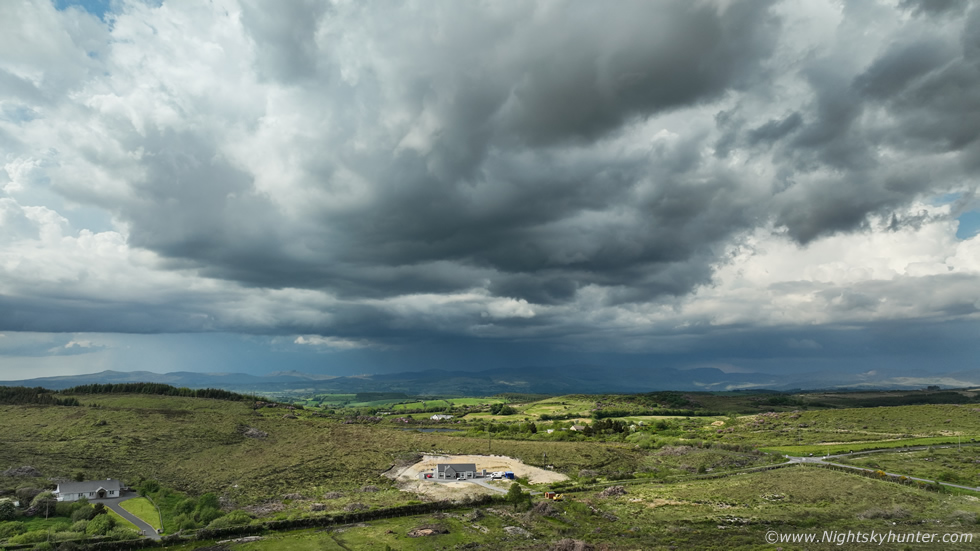
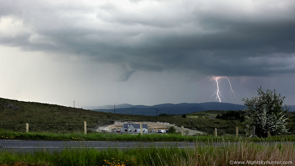
The ground was hot outside, Rhua had to find some wild grass to sit on to keep cool. Much of the lightning was unseen as it discharged either deep inside the dense precip core or way up inside the thunderheads so the majority were in-cloud, we could tell by the acoustics of the thunder. We both spotted our first c-g, a lovely bolt with a zigzag shape, this helped us know exactly where to focus our attention. I let the drone settle, centered the camera on the location we observed the recent strike, zoomed in a little then began recording three minute segments of video over and over.
We had a nice view of sunlit countryside in front of us and in the distance were the dark outline of the mountains bathed in a moody thundery blue shadow where the most active storm was brewing aloft. We observed another c-g, I heard Nigel's trigger fire which confirmed it, I knew I had to have that one on video, when I played it back later I had. I decided that if I captured just one bolt on video then this day would be considered a success, the Mavic 3 done a great job once again, video still above filming at 30 frames/sec, a well defined positive c-g.
 |
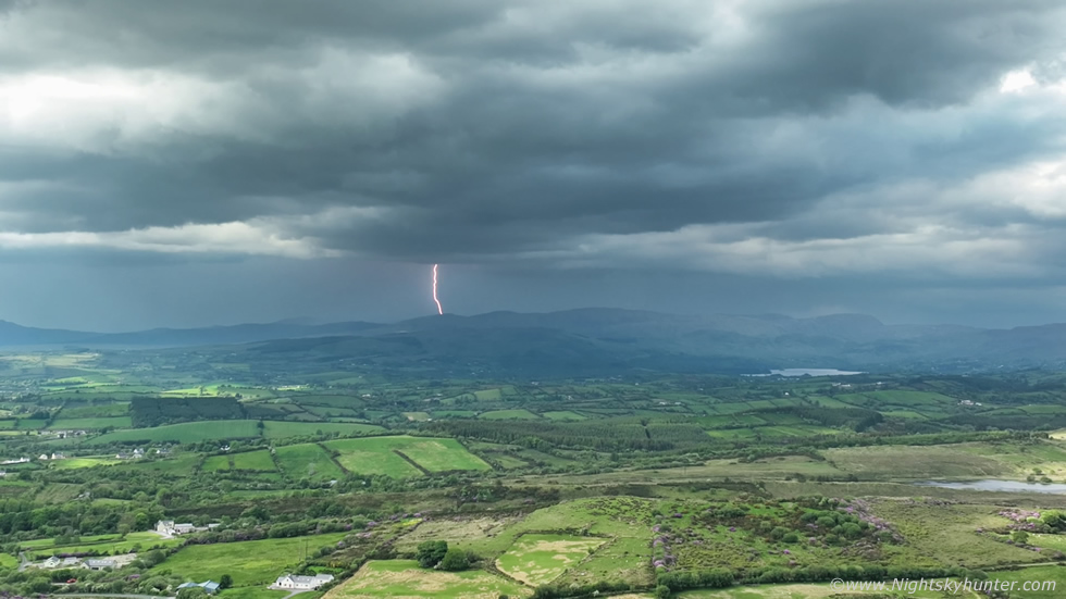
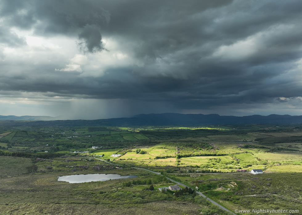
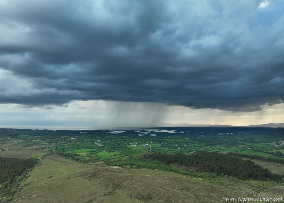
I burned through an entire battery recording video for bolts then landed for a break. Half an hour later the sky in front of us began to develop structure and darken, then the clouds parted and the sun came out to reveal an impressive new development in the form of a new storm building along the flank of the distant storm and in the process of merging into the principle storm. We where directly on the convergence zone and under the atmospheric conveyor belt where new updraughts were exploding to life.
I got a fresh battery into the drone and was back in the air. I thought this scene was gorgeous and of very high natural contrast with the dabbled sunshine lighting up the lush Donegal countryside with convective shadows and above a big storm cell. Despite having a relatively high base this did have interesting structure on the updraught base and a new precip core, red on radar already, falling to the surface in moody light against the dark background. The scene was too large to fit into the single wide angle camera so I recorded a video segment panning around the storm cell.
 |
Drone camera panned high to reveal the crisp updraught plume and growing anvil spreading out. When I sped up the video footage that cloud structure under the base was rotating for a long time, how we didn't get a funnel cloud from this is beyond me. This moment would become the main structure scene of the day while occasional thunder still boomed from that core over the mountain.
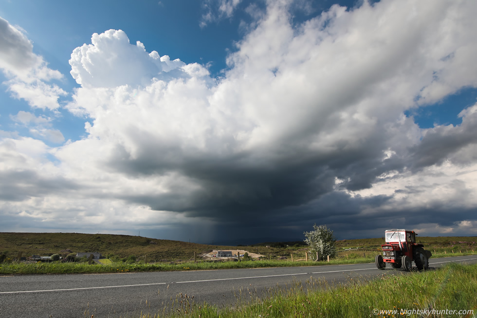 |
The new cell was slowly drifting away and to the right joining the big storm. DSLR 15mm wide angle ground capture, the passing old tractor really accentuated the Donegal imagery with the storm.
 |
We had already been here two hours shooting, our storm was still active and a new storm was beyond us to the west in the distance rumbling near Belleek. Nigel and I were astonished at the amount of rain falling from this storm over this area, before we had arrived it had already been raining there for over two hours and by now it had to be at least four hours of constant rain without a break. We felt sorry for anyone living under that storm, what a day it would have been for them, new core after core in a never ending cycle, red and white on radar constantly, surely there had to be major flash flooding coming down those hills to low levels.
Here storm clouds where moving from left to right and on the right side from right to left, here's the whole storm cluster just sitting there, this was a rain making machine. That lovely white cottage to the lower right is very lucky indeed because a few miles down the road the situation would have been a nightmare. We would later find out that 100mm of rain fell in an hour and a new hiking trail built on the flank of Errigal was washed away by flash floods, rocks and stones, the local ambassador said he was shocked by the weather, really? sure this was trending on the models all day and radar confirmed a significant event was happening, it was not surprising at all.
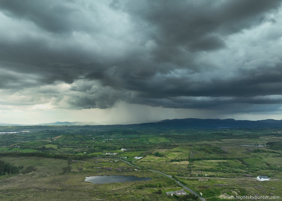 |
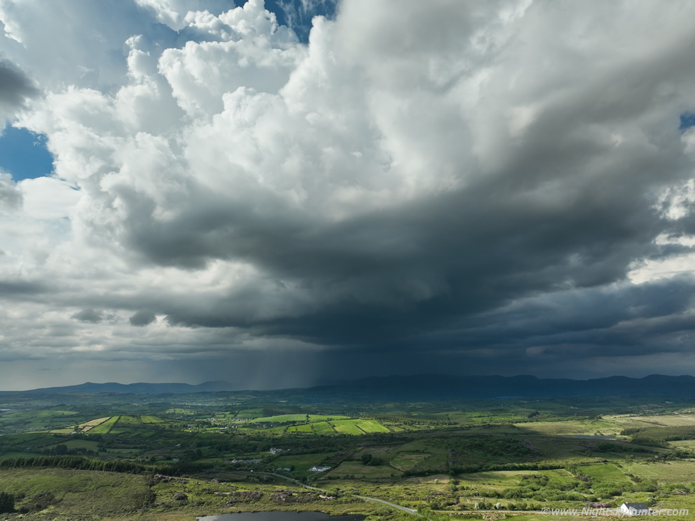
There was also a big storm over Sligo and our twin storms were still active in front of us, this must have been hour three on location and now I was down to my last battery. A merger of two storms was taking place on the convergence zone, I liked the structure here, the lowering centre left was also slowly rotating when I previewed the footage. There were new lightning strikes in that bright region of sky below and left of the lowering and still random bolts over the mountain on the right, this storm had been producing sporadic lightning and constant rain for approximately five hours now.
 |
Another image of that updraught base merger structure ten minutes later, that core may have been inland of Killybegs, my battery was down to 20% and I was getting the low battery warning so I decided to land the drone, all three batteries had been used, and each battery lasts approximately 40 min's. Now it was time to focus my attention on ground video.
 |
I set up the full frame Canon 5D Mark IV with 50mm F/1.8 lens, stopped it down for sharpness, then began recording video, something I haven't really done much of before with this camera as I mostly use it for stills. I would let it record for three to five minutes at a time, stop the recording, then start a new session. At this stage I wasn't concentrating on the video and also got distracted by other things, Rhua needed fed and checked on, I wanted a snack to keep my energy up and another storm had formed to the left of this one which began rumbling and stealing our attention for a while.
I didn't think I had anything on the 5D until I got home, I had that much video it took me three nights to review every second of footage looking for bolts. During the above sequence it was late at night, I had been staring at the lap top screen for a long time finding nothing, I was tired and frustrated, how could that camera not catch on bolt?, I was literally going to pause this clip, then delete all the DSLR videos as my patience was gone, just went I was about to stop the footage I saw this. The most beautiful c-g I've captured in years, a negative cloud to ground strike over the hills with second order branching with inflow lowering on the left, this made my entire day.
 |
This was the other storm merging into our area of interest, it was very high based but had interesting laminar structure along the base and was rumbling loudly. I managed to find a battery with 30% power left and use it to get a few aerial images as our view of the surface was blocked by a hill, the core was over the west Atlantic. I got a call from Paul Martin, he was on his way and was on this very same road and would meet us soon, he had been busy at work and hadn't heard a rumble all day, we hoped that would change when he arrived.
Paul arrived and soon after thunder broke his drought, then as we watched the distant storm we noticed one towering cumulus slowly approach from behind, literally ten minutes later it was producing spits of rain and thunder. Then it was overhead and we where in the danger zone, three more loud rumbles preceded by in-cloud flashes inside the updraught crossing our zenith, lucky for us they were not c-gs, we sensed danger then took cover inside Nigel's car. Then an absolute monsoon downpour which came out of nowhere, I had to run outside in it and grab my camera and tripod, I've never felt rain like it in years, massive raindrops which felt like they were attacking you, it was like a tropical storm, that was unreal.
 |
The storm moved away and I shot this of the tops of more convection approaching us on the now weakening convergence zone. The atmosphere was winding down, the thunder stopped, and the clouds began to take on a more stable laminar look as the last of the instability vanished. What a day of chasing it had been of beautiful convection, scenic countryside, rumbles of thunder, c-gs and most of all a storm which produced five hours of rain and hail over one of the most photogenic areas of Co. Donegal. The drive home seemed to go in fast as we chatted about the storm, our experiences, camera gear etc and before long I was back in Cookstown. A big thanks to Nigel McFarland for doing all the driving today, it was a great road trip and our first long distance storm chase of the season, I'm sure there will be plenty more to come.
Chase footage, mostly phone video on the drive up and the rest is drone footage of the convergence zone thunderstorms sped up by a factor of x8 times to examine the cloud motions and rotation. When I arrived back home I checked the charts which showed that the next day would be another chase day however more about that on the next report, thanks very much for reading.
Martin McKenna